
Everywhere I go both coasts wit toast
When you fly trans-Atlantic, why does the plane not go straight? One would think the shortest route would be a straight line from say NYC to London… but the plane makes a curve…
What is a straight line on the globe may appear as a curved line on a flat map. Use a globe and hold a piece of string tight against it with one end at each of the two cities you are flying between. You might find that this gives you a very different path than if you drew a straight line on a map. (…)
For example, a direct line from Toronto to Tokyo goes through Alaska and Siberia. On a flat map with the north pole at the top, this would look like an arch. (…)
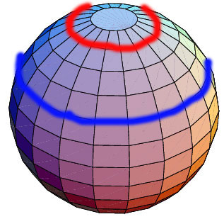
Notice that the red line is shorter than the blue line. The sphere has a smaller circumference as you get closer to either of the polls than it does at the equator (closer to the blue line)
If you were to fly directly to your destination on a transatlantic flight (let’s say along the blue line), you would have to fly a much further distance than if you bowed up north over Greenland (and flew closer to the red line) for a bit.{ Askville | Continue reading }
North Atlantic Tracks (NAT) are trans-Atlantic routes that stretch from the northeast of North America to western Europe across the Atlantic Ocean. They ensure aircraft are separated over the ocean, where there is little radar coverage.
These heavily-traveled routes are used by aircraft traveling between North America and Europe, flying between the altitudes of 28,500 and 42,000 feet, inclusive. Entrance and movement along these tracks is controlled by special Oceanic Center air traffic controllers to maintain separation between airplanes.
The primary purpose of these routes is to provide a Minimum Time Route. They are aligned in such a way as to minimize any head winds and maximize tail winds impact on the aircraft. This results in much more efficiency by reducing fuel burn and flight time.
To make such efficiencies possible, the routes are created daily to take account of the shifting of the winds aloft. (…)
Concorde did not travel on the North Atlantic Tracks as it flew to the United States from the United Kingdom and France from a much higher altitude, between 45,000ft and 60,000ft. The weather variations at these altitudes were so minor that Concorde followed the same route each day, traveling to and from Europe to North America on fixed tracks.

